The Last Bus to Everywhere
About a month ago, Stagecoach in South Wales – part of the UK's largest bus operator – announced that they would be closing their depot at Brynmawr in Gwent. 77 jobs are at risk following this decision, which Stagecoach have attributed to the cut in Welsh Government subsidies. The company are also dropping fourteen services and reducing the frequency of another eight.
In a statement on the BBC Wales News website, the company's managing director John Gould said:
Make no mistake, ultimate responsibility for the loss of bus services and jobs lies firmly at the door of the Welsh government following years of cuts to bus investment.
We deeply regret the impact this will have on our customers and local communities. Instead of protecting and supporting bus travel, ministers' misguided decisions have dealt a body blow to the country's public transport network and wider economy.
People across Wales have repeatedly warned the government about the consequences of their actions, but sadly they have refused to listen.
The BBC story went on to give a full list of the routes which will be cut:
- X16 Risca - Cardiff
- X32 Maerdy - Cardiff
- X78 Merthyr Tydfil - Pontypridd
- 244 Pontypridd - Bridgend
- 411 Tynewydd - St John's High School</l
- 7 Blackwood - Ystrad Mynach - Pontypridd
- C16 Caerphilly - Nelson
- C17 Bargoed - Caerphilly
- 538 Blackwood - Penybryn
- 30 Brynmawr - Cwmbran
- 64 Newport - Underwood
- 74 Newport - Chepstow
- X74 Newport - Chepstow
- 60 Newport - Usk
I'm not going to analyse the financial background to the present situation. I might go into more detail in another posting, but I'll need to do a fair bit of research first. In this entry I just want to look at bus services in general; I'll examine the situation in specific areas in subsequent entries.
As I've pointed out several times already in this blog, travelling in a roughly north-south direction through the Welsh Valleys is a relatively simple affair. Most of the major roads lead to Cardiff (eventually!), and the railway lines converge there as well.
The Valleys themselves exhibit a classic example of what town planners refer to as ribbon development: 'building houses along the routes of communication radiating from a human settlement' (definition from Wikipedia.) The historic development of this area was driven by the rapid growth of industrial communities during the Victorian era. My home town, Aberdare, mushroomed from a small farming community at the beginning of the nineteenth century to a large industrial town in a little over half a century. Have a look at these census figures for the Parish of Aberdare alone:
1821
1831
1841
1851
1861
1831
1841
1851
1861
2,063
3,961
6,461
14,999
over 32,000
3,961
6,461
14,999
over 32,000
In Merthyr Tydfil, the next valley to the east, industrial development began earlier, with the coming of the ironworks. Here are some comparable figures for the Parish of Merthyr, which didn't even include substantial districts like Cefn Coed or Vaynor:
1801
1821
1841
1851
1821
1841
1851
7,705
17,404
34,977
46,382
17,404
34,977
46,382
To the immediate west of Aberdare, the Rhondda Valleys started industrialising slightly later as the demand for steam coal increased. The population remained steady for the first half of the century, and then exploded almost overnight. These are the census figures for the Parish of Ystradyfodwg, which included parts of the Rhondda Valleys:
1801
1811
1821
1831
1841
1851
1861
1871
1811
1821
1831
1841
1851
1861
1871
542
576
647
542
748
951
3,035
16,914
576
647
542
748
951
3,035
16,914
This almost exponential growth was typical of the rapid population increase across South Wales as people from across the UK came here to work, first in the ironworks and then in the coal mines. In turn, these booming industries gave rise to secondary employers – railways, crafts and trades, shops, banks, pubs, and so forth. This resulted in a huge burst of house-building, and the peculiar geography of the Valleys meant that ribbon development was the logical option. Long terraces of small houses perched on the hillside are probably everyone's mental picture of a typical Welsh Valleys town, and they sprang up largely because of the area's topography.
However, Aberdare isn't really a representative Valleys town, because it sits on an alluvial plain at the base of a U-shaped post-glacial valley. The true Valleys towns are places like Mountain Ash, Treorchy, and Tonypandy. Like Aberdare, these places grew massively in a relatively short time, and this pattern of ribbon development can still be seen today, where the streets rise steeply along the narrow V-shaped profile. The nature of the terrain meant that all the railway lines and main roads had to be crammed into the point of the V, running parallel with the river on the valley floor.
These towns are linked together by railway lines and/or direct bus routes, all heading in the general direction of Cardiff, Newport or Bridgend. This makes it fairly easy to travel in a (roughly) north-south direction.
I've put Figure 1 together using several scans from Google Earth, and added the railway lines myself as red lines. I've taken my information on passenger and freight lines from Baker (2010). My diagram doesn't follow the exact course of the railways (that would require a much larger scale), but it does illustrate the Cardiff-focused nature of our railway network:
[caption id="attachment_12027" align="aligncenter" width="640"]
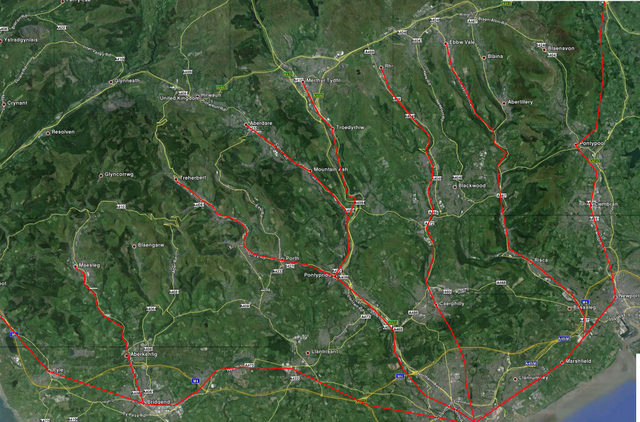 Figure 1: The passenger railway lines of South Wales. Note that they all converge on Cardiff[/caption]
There isn't a lot of immediate potential to expand the network, either. The only reason Aberdare is served by passenger trains is because Tower Colliery was still in operation during the late 1980s, and the line was being used for freight traffic. The same applied to the reopening of the Maesteg line. The return of passenger services to Ebbw Vale – or, to be exact, Ebbw Vale Parkway, some distance from the town centre – was only possible because the line connected the steelworks to the main line just outside Newport. Building new railways is an extremely expensive business, so the only viable option is to upgrade old freight lines for passenger services. However, there aren't many freight-only sections left, as you can see from Figure 2:
[caption id="attachment_12029" align="alignnone" width="640"]
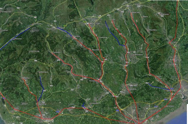 Figure 2: Freight-only lines (including disused sections) are marked in blue[/caption]
Compare that with Figure 3, which shows the rail network at its height a century ago:
[caption id="attachment_5078" align="aligncenter" width="646"]
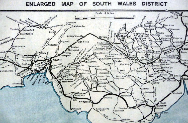 Figure 3: The railway network in South Wales c. 1910[/caption]
Dozens of useful but 'uneconomic' branch lines, like the one under the mountain between Aberdare and Merthyr, were casualties of Dr Richard Beeching's review of the rail industry. I referred to that particular closure in my letter to the Western Mail last month. I also referred to the gap between the railheads at Hirwaun and Cwmgrach, which would need to be bridged before trains could ever run to Swansea again. You can see that gap for yourself, in the north-west corner of Figure 2. Before Beeching's axe fell, there was a direct connection across the Heads of the Valleys, which you can see just below the scale bar in Figure 3.
There has been talk of reintroducing passenger trains to Bedlinog, a small isolated town at the head of the Taf Bargoed Valley, sandwiched between the Merthyr and Rhymney Valleys. Freight trains currently serve the opencast mine at Ffos-y-fran, running through Trelewis and skirting Nelson before feeding into the Valley Lines just south of Ystrad Mynach. It sounds like a sensible addition to the Valley Lines network, on paper at least.
Further west, the Bridgend Valleys Railway Company hopes to reintroduce passenger services between Pontycymer, high in the Garw Valley, and Tondu, just north of Bridgend. According to their website, they hope to accomplish this 'within the next 10 years.' However, this will be a heritage railway, running more as a tourist attraction than as an integral part of the passenger infrastructure.
In the Rhondda Fach, a few miles west of Aberdare, the freight line from Maerdy Colliery was pulled up soon after the pit closed. Other branch lines were torn up as they outlived their perceived usefulness. On the whole, then, there's not a lot of scope for reintroducing passenger services in much of South Wales. That means that, for many communities in the Valleys, the only public transport available is the bus.
Bus routes, like the railway lines that preceded them, tend to meet at southern towns like Bridgend, Pontypridd, Caerphilly or Newport before they all converge on Cardiff. If you were to look at the schematic representations of Wales' public transport network, you could almost be forgiven for thinking that our capital city is a major transport hub. In fact, there are fairly good lines of communication running north-south, mainly because that's the way the system developed over time.
Travelling from east to west, however, isn't nearly as straightforward. In the words of the song, there are mountains in our way. The Victorian engineers got around this problem by building impressive tunnels which allowed trains to travel from east to west. The entrance to one such tunnel, at Cwmbach (near Aberdare) can still be seen today, although it has been sealed off for safety reasons:
[caption id="attachment_12030" align="aligncenter" width="646"]
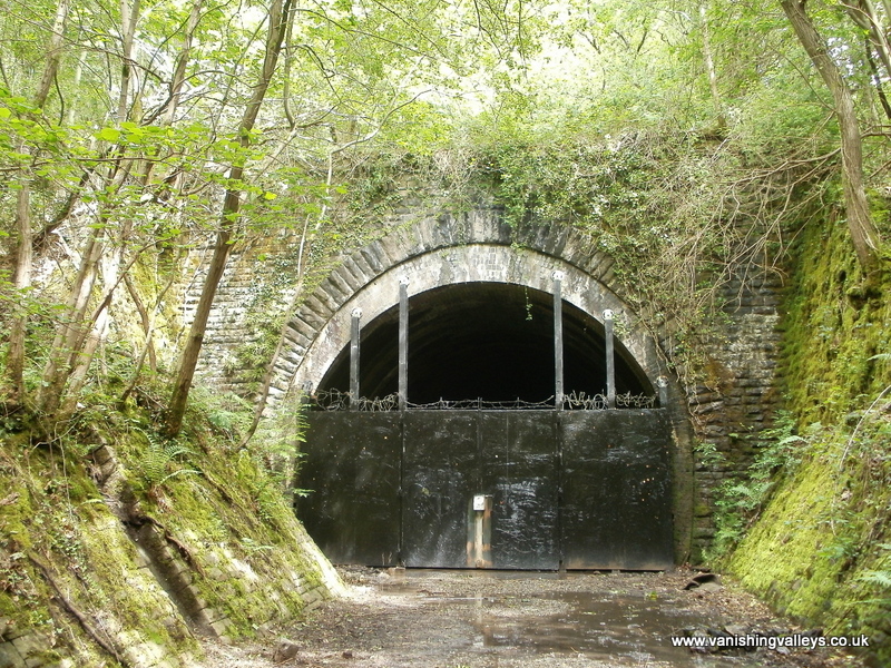 The Merthyr Tunnel entrance[/caption]
There used to be a very long rail tunnel between the Rhondda Valleys and the Afan Valley, enabling coal to be transported to the docks at Swansea. Like the Merthyr Tunnel, it's long gone.
Naturally, where the trains went underneath, the buses have to go over the top. On the northern edges of the Valleys, these routes involve steep climbs over mountain roads, and in heavy snow the roads are often impassable. Furthermore, some valleys end blindly, with no way over the top. The Garw Valley, north of Bridgend, is a good example of this; once you reach Blaengarw, there's nowhere else to go.
Further south, the main towns (for example Bridgend, Pontypridd and Caerphilly) are served by trains – however, the lines all converge on Cardiff, and the only way to get from east to west is by bus. Some of these east-west routes are on the Stagecoach 'hit list' at the moment. One of them is the 244 service, which runs between Pontypridd and Bridgend. I've taken this little route diagram, and the others that follow, from the Traveline Cymru website. It's still a pain to negotiate, but it does have some nice features – and a Google Earth-based facility to visualise the route on the ground is one of them.
Here's the 244, so that you can see the route for yourself:
[caption id="attachment_12061" align="aligncenter" width="526"]
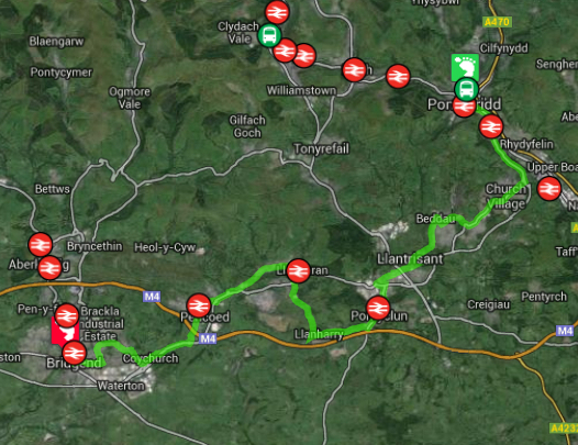 Figure 4: The 244 route between Pontypridd and Bridgend[/caption]
This service currently operates hourly from fairly early morning to early evening six days a week. When I say 'early evening', the last one leaves Pontypridd at 1742. Anyone running late when they finish work – or attending a late lecture at the University of South Wales – will be left high and dry. Travelling on a Sunday is far more convoluted, involving changes of buses and/or trains to get to your destination, and you can forget any idea of an early morning or late evening journey!
As you can see from Figure 4, this particular bus route runs close to several railway stations. Unfortunately, there's no direct rail link between Treforest and Pontyclun. The only way to get from one place to the other by train is via Cardiff.
(Pontyclun itself – like Llanharan and Pencoed, also on the 244 route – is served by just one train per hour in either direction, Mondays to Saturdays, and one train every two hours on a Sunday afternoon. Lots of trains pass through these intermediate stations, but most of them don't stop there. Having said that, trains didn't stop at Pontyclun at all between November 1964 and September 1992, so there's been some degree of progress!)
The 244 is a very important service for people living along its route, because it operates via the Royal Glamorgan Hospital. That's not the only key feature, of course; it's the only direct link between the intermediate towns on the route. It will probably be possible to travel between Pontypridd and Bridgend after the end of July, but it will almost certainly involve a series of short journeys and changes of bus. It's hardly an ideal solution. Mike Powell, the sole Liberal Democrat member of Rhondda Cynon Taf County Borough Council, has already written in the local party's blog about the potential impact this cutback will have on the people of Pontypridd and the surrounding area.
Let's look in the opposite direction for a moment. At present, Stagecoach operate a bus from Pontypridd and Blackwood, via Nelson and Ystrad Mynach. From Blackwood, it's possible to explore the Eastern Valleys in a variety of ways. It's a convenient bus interchange in a fairly large town:
[caption id="attachment_12062" align="aligncenter" width="646"]
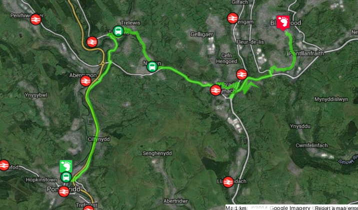 Figure 5: Service 7 from Pontypridd to Blackwood[/caption]
This is another link between adjacent valleys which aren't connected by railway lines. Like the 244, it runs hourly from (fairly) early morning to early evening six days a week. (On a Sunday, this same journey would involve a combination of trains and buses. It sounds like yet another case of 'nice work if you can get there' to me.)
The 7 is another of the buses which Stagecoach are axing at the end of July. Once again, people are going to be left in limbo unless another operator steps in to run the service. As if losing its cross-valley connection isn't bad enough, the little town of Nelson, situated between Abercynon and Ystrad Mynach, is going to lose another bus service. The C16, which runs between Nelson and Caerphilly, is being cut at the same time.
[caption id="attachment_12063" align="aligncenter" width="646"]
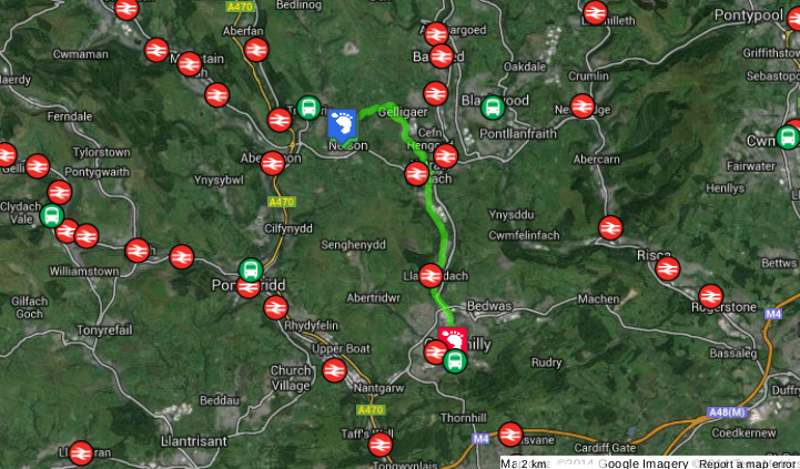 Figure 6: The C16 route between Nelson and Caerphilly[/caption]
I don't know the Nelson area well enough to go into the social implications of these cuts; however, the economic and environmental consequences are obvious to anyone who takes a moment to think about them. Many people will be unable to use public transport to get to work, or college, or hospital, or to go shopping, or to visit family and friends. As you can see from the maps I've reproduced above, the railway simply doesn't offer a viable alternative. The logical result is that the number of cars on the roads will simply have to increase. It's not rocket science, it's internal combustion engine science.
In Nice Work If You Can Get There I told you about my email correspondence with Professor Kevin Morgan of Cardiff University School of City and Regional Planning. I'd read a piece in the Cynon Valley Leader, towards the end of 2012, about Prof Morgan's vision of a 'South Wales Metro.' This would involve connecting the existing railway lines by a system of cross-valley light rail links, similar to the high-tech tram system which I saw in action in Manchester a month before I came to write that entry. Prof Morgan's paper was inspired by the way the city-region of Stuttgart in Germany has tackled the issue of public transport (Frank & Morgan, 2012.) The area in question is quite similar to South Wales, with a large number of scattered towns centred on a large city, and quite challenging topography to overcome. However, the Germans have decided to tackle the problem head-on, rather than tinkering at the edges, which is usually the British approach to big capital projects.
In June 2013, the Welsh Government unveiled their version of the idea, complete with a London Transport-style schematic of the overall system (Law, 2013.) In February this year, it was announced that the scheme had taken a first step towards becoming reality, with news that the first stage would be an £18m link between the city centre and Cardiff Bay (Sanders, 2014.) Needless to say, it's already run into opposition from people in the suburbs, who don't want it to be built anywhere near their homes.
Hang on a minute, though! Isn't Cardiff already adequately served by public transport? All the railway lines converge at the city centre, with up to six trains an hour running south of Pontypridd and up to four an hour running south of Caerphilly. Network Rail and the Welsh Government are spending over £220m on improving and 'future proofing' the rail network (to be completed in 2015.) Then factor in all the north-south bus routes, the east-west bus routes, the train service to the Bay, the bendy buses which run every ten minutes… Does the city of Cardiff really need any more public transport provision?
I would argue that it makes far more sense to start building a 'South Wales Metro' in the Valleys, and integrate it into the Cardiff suburban network later on. Improving connections between the valleys would have immediate economic benefits. We could start by connecting Pontypridd to Ystrad Mynach, utilising the existing railway lines at Abercynon and Nelson and connecting them by some new-build track parallel to the A472. After that, we could extend the line to Blackwood and Pontypool. That would replace one of the bus routes which Stagecoach are so keen to get rid of. The new electric trams wouldn't be subject to the frequent traffic hold-ups which occur in the narrow streets of our old towns. We could start building a clean, green transport infrastructure, linking towns and villages which haven't seen trains since the 1960s. Imagine how much time you could save if you wanted to travel to the Midlands or the North of England, by not having to go into Cardiff first.
Once we've finished that stretch, let's do the same going the other way. Let's build a new line from Pontypridd to Pontyclun via Llantrisant, restoring the historical link between the Taff and Ely Valleys. While we're at it, let's restore the old freight line between Taffs Well and Aber, which would enable people to travel between the Taff and Rhymney Valleys without going into Cardiff.
Let's not stop there. Let's reopen the old tunnels and connect the towns at the heads of the valleys with the railway line to Swansea and West Wales. While we're at it, let's take another new line the other way, through Tredegar, Ebbw Vale and Brynmawr, and feed it into the main line at Abergavenny.
There's more: as the system took shape, the Welsh Government could introduce an Oyster-style card which would be valid on all trains, buses and trams in Wales, enabling quick and cost-effective cross-modal transfers at the major interchanges.
I'd love to see a really courageous, forward-looking, independent Welsh Government given the powers to initiate such an ambitious scheme. They could build a light rail system that would spread its tendrils throughout the nooks and crannies of this geographically challenging area, in the same way that Manchester's tram system is growing into the suburbs of Cheshire and Lancashire. It would create a great many jobs during the construction process, and deliver a huge economic boost to an area which has been in economic decline since the 1920s. While the politicians in Westminster continued to wrangle over the fine details of HS2, we in South Wales could start work on a transport system which would say to the world, 'Here we are!'
Needless to say, here in the Real World, it's much easier to go backwards instead. The ConDem austerity measures have hit this little country very hard already, and the drastic measures announced by Stagecoach are one of their latest manifestations. It's time for Wales to start punching its weight in Europe, and grab some of the enormous funding which always seems to be available for capital projects on the continent.
I'll keep you posted on the situation once Stagecoach withdraw their services at the end of July. Presumably another operator will have to try and fill the void – but without the subsidies from Cardiff, how long will they be able to keep them going? Meanwhile, I'll look at the state of our local bus services in more detail in forthcoming posts. Watch this space…
REFERENCES
Stagecoach to cut 14 services after depot closure, BBC News website, April 17, 2014
BAKER, S.K. (2010) Rail Atlas: Great Britain and Ireland (12th ed.) (Hersham: Ian Allan.)
FRANK, A., MORGAN, K. (2012) Reinventing the City: The art of metro-governance in the Stuttgart region. (Cardiff: Cardiff School of City and Regional Planning.)
LAW, P. (2013) South East Wales Metro vision unveiled to improve transport links and boost economy, WalesOnline, June 18, 2013
SANDERS, A. (2014) South Wales Metro system: First steps will be £18m improvement to Cardiff Bay and city centre links, WalesOnline, February 17. 2014


Reblogged this on WelshBiz is a Welsh Business Community, Welsh Business Marketing Wensite, Welsh Business Blog & Welsh Business Social Media Platform for Welsh Business News, Welsh Business Advice, Welsh Business Events, Welsh Networking Events & Welsh Events Website for Welsh People & Welsh Businesses!.
ReplyDeleteThanks for that, wow! :-)
ReplyDeleteNo problem!
ReplyDelete